Running with the Wind Turbines

Between Llanidloes and Newtown in the county of Powys lies a fifteen kilometre ridge, mostly above 500 metres and peaking with a slight bump at a respectable 584 metres at the summit of Pegwyn Mawr. This translates as ‘large pole’ and believe it or not, sticking out of the summit cairn is indeed a large pole. It’s hard to believe that the pole is more ancient than the name, or that you would name a mountain after it, but then why would you call a rounded moor (albeit with steep lower slopes) large pole if one didn’t exist? If anyone knows, it would be great to hear. Perhaps it really didn’t have a name, and the Ordnance Survey snuck one in.

Last Saturday, the snow still settled on the lower fields and forming drifts one or two feet high across the upland tracks, I went up to cross this ridge. Running first along Glyndwr’s Way from Llanidloes east and then south, the track then shoots straight up the hill, the snow now coating the ground and the sheep looking miserable trying to find the grass beneath.

Above 500 metres there were infrequent blasts of hail and snow, interspersed with great views towards Plynlimon and the hills far away in the north. The grass poked through the white, but not all was frozen, and I was soon struggling through mushy bog, my running shoes submerged.

IMG_20150117_112505

Most of the ridge is taken over by a large windfarm, though the turbines themselves are not as large as most I have seen elsewhere. This meant that, on my route along the ridge, I was soon giving up the bog for a track, which seemed less invasive now that it blended seamlessly into the white grass and heather. The turbines rotated rhythmically on either side, and give you that slight quickening of the heart when you stand underneath one. The blades fly down towards you and then are swept skywards again, suddenly, just at the moment you imagine them breaking off and thudding into the earth.

There are quite a few wind farms in mid-Wales, and from any hill they are visible. I like running next to them, and am glad they are here. I didn’t live here before they were built, so perhaps locals have more reason to object, but they are no more unnatural that sheep or roads, and I doubt anyone would prefer having a coal-fired power station or an oil refinery nearby.

The northern end of the ridge started to become brown and green as I dropped in altitude and picked up other tracks and then a road down into Newtown. Frozen patches turned out to be covering black water and these broke frequently as I stepped on them, providing my feet with a special kind of cold spa treatment.

The Newtown side of the ridge is far gentler than the western side I had ascended. From that side the ridge is more pronounced, the wind turbines more obvious as waving guardians on the top. I have wanted to do this running traverse since I came here, and I ran from my door. There is no doubt the wildness of the ridge is reduced by the wind turbines, both the beasts themselves and all the countless access tracks. But I would rather run with them, than whatever the alternative is. After all, those of us who love the outdoors are used to being battered by the wind – it feels like getting one back to get home and have a cup of tea heated using the energy provided by that same force.

Snow comes to Powys

It snowed here yesterday for the first time this winter. Starting around mid-morning, settling for a while, hesitating, and then going for it again in the afternoon. At five, finishing work, there was the slightest blue light remaining in a clear sky, and the snow was still coating the fields, the temperature sub-zero.

I went for a run along the small single track road leading up the river Severn, intending to cross by the next bridge and come back on another road. The Severn is small here, barely two metres wide, and the rush from the days weather could be heard as background noise as I began.

The fields were white and still, and reflected the little light there was, bouncing it back and forth between them and the hazy sky to prolong the day. It was cold and there was no wind. I turned my head torch off and the visibility increased. The sky was rapidly darkening but it was easy to see the difference between the white fields and the black slip of a road I was on.

I continued in this way for some time, past houses and their kitchen lights, and once startling a dog who broke the winter silence as I ran past. My hands were cold under gloves and I sometimes turned the torch on when I heard water in front of me, to check the road was not too submerged before I went on.

I crossed the bridge and began the return leg as the clouds closed in and light snow turned to heavy sleet, rushing past my torch in white stripes, my eyes unable to pick out individual flakes amidst the maelstrom. I was soon soaked, and unable to see anything but the ground directly in front of me, in a circle of torch-light.

I tried again turning the torch off and could see much better, the orange glow from the town reflected onto the clouds and showed up trees on either side of me. The sleet shower was now just a noise, and a sensation on my clothes. I couldn’t see anything apart from the nothingness that meant the road. I ran at it.

The sleet eventually eased and I got back to the street lights. There’s something to be said for running in the dark, especially if you have snow to light your way.

Down the RABbit Hole : The 2014 Rab Mountain Marathon

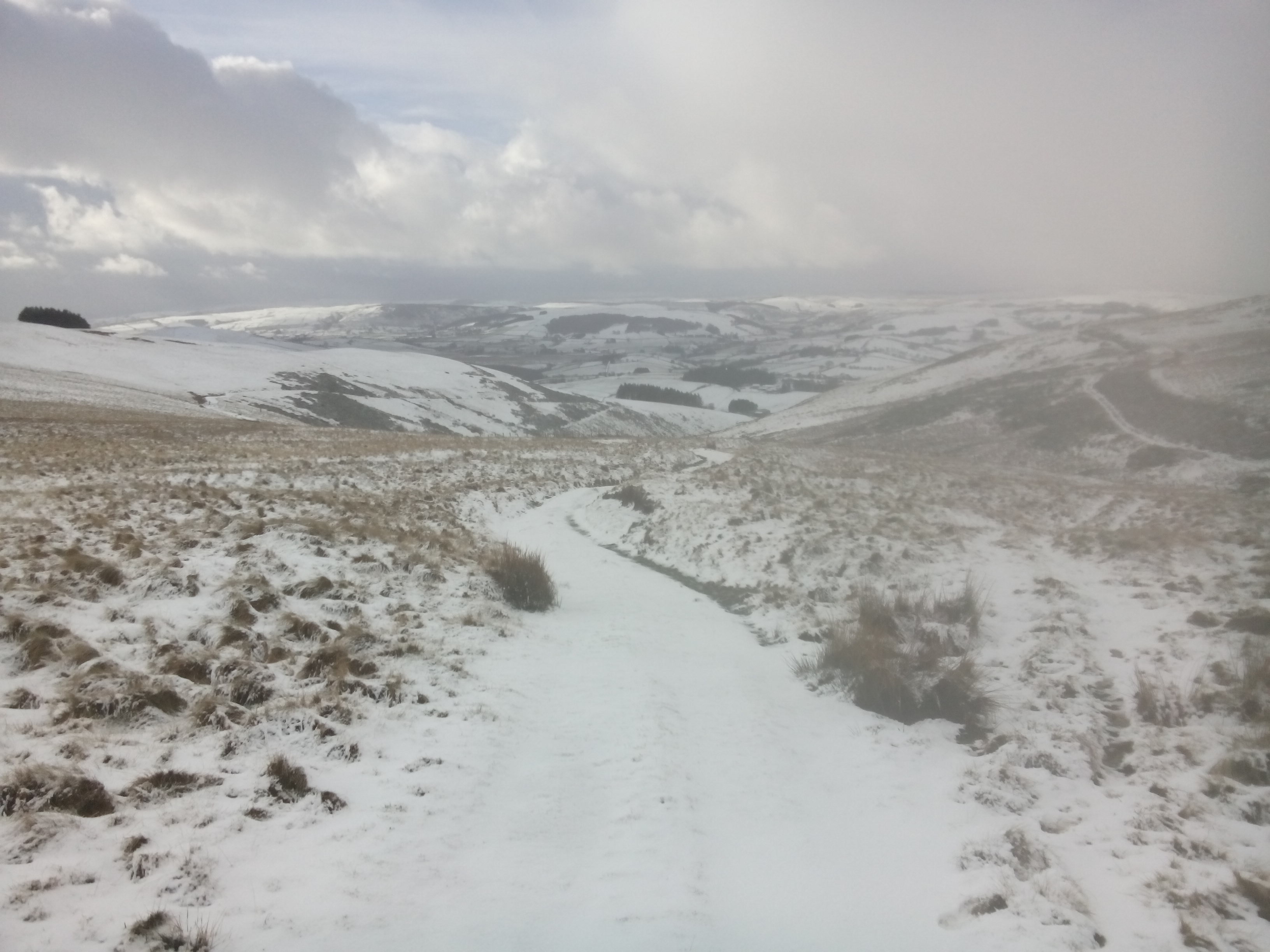
I approached the distinctive summit cairn of Thornthwaite Crag in thick cloud, happy to find a distinctive point on the otherwise gently sloping summit ridge that links High Street to several other Lakeland peaks. Huddled behind the wall were several walkers, kitted out in waterproofs and hats, with large bags. ‘You’re brave to be wearing shorts,’ one shouted at me above the wind. I looked down, I was indeed wearing running shorts and a long sleeved shirt, not clothes to hang around in. I ran off down a path after smiling at the group and waving. Thinking about it afterwards, I should have said ‘actually this is the driest September on record, so I wanted to make the most of it.’ But you never think about it at the time.

At this point I was half-way through my time on day 1 of the Rab Mountain Marathon, a two-day score event based somewhere two hours from Manchester. This year, in the far eastern Lake District, there was a healthy mix of mountain crags, boggy uplands, and thick unrunnable heather to make any route choice a challenge. The map was the same for both days, but on each day different controls were ‘active’, and you only found out which these were as you began. Then you have a set time – either 7 or 6 hours on day 1, and then 6 or 5 hours on day 2, depending on whether you were doing the long or short course.

The greatest challenge for me is trying not to get carried away at the start and run off without planning at least the first section of a reasonable route – not only which controls I thought I could get to and in what order, but whether I could get to the finish in time, and what I could afford to cut out in the event of either overestimating my ability, or getting horribly lost. Luckily there was what seemed an obvious objective – at the top, furthest away section of the map, were two of the controls with the highest available points, relatively close together. Linking the start to these controls, and then from there to the overnight camp, I linked up a bunch of other controls that sort of marked out a route. An unlikely sightseeing itinerary.

Running up the first stretch, along a boggy stream and then higher up, following the line of rushes and finally under some crags and up a steep slope to the wide summit of a boggy ridge heading north west, I was finally alone in the cloud. This area is the Shap Fells, and is infrequently visited in comparison to the rest of the Lakes. I saw no one until I dropped down to a track and headed down to the Haweswater Reservoir, past a large group of school children and a few other walkers. The reservoir soon appeared, brooding grey with Kidsy Pike behind. I followed a wall and began a gruelling ascent to the summit of Mardale Ill Bell. This was the remoteness you can get from a mountain marathon, taking part in an event with hundreds of others, knowing there will be people to chat to that evening and swap stories with, yet able to run and climb alone for much of the day.

DSC_0033

An hour or so later, descending out of the cloud into another valley, the distant sun finally broke through and Windermere appeared in the distance. With a gentle slope, spongy underfoot I practically flew down the four kilometres to the next control and then, in striking contrast, began the steepest ascent of the day. Using hands to grip the grass and staring at the ground, up I went, with two hours until my time was over and two mountain ridges to run over and down, it was a hard push.

I began to see other people as I crested this ridge and followed the path along, and then suddenly there were more than ten runners, all looking for the same spot as I was. It felt like a crowd, like getting into the London underground. There were people more regularly now, heading off in a bizarre combination of compass bearings to find those last one or two controls and associated points before they had to make the final dash for the finish. I was tired by this point, and my legs were uncooperative, but I put my head down and jogged ferociously for the finish, joining a path over the last hill and dropping down into Longsleddale and the campsite.
Dumping a backpack on the ground and stretching always feels good after a race, but after 7 hours of running it feels transcendent. Feeling different muscles I also had that little niggling thought that I still had 6 hours of running the next day. But that was more than 12 hours away, and with plenty of time for food and sleep in-between, I put it out of mind. Slowly the campsite began to fill, and those of us there got to watch the constant flow of runners down the steep hillside up the valley, where a steep final checkpoint had been placed to lure people in. Pairs of runners cooked together, and solos like me made friends. Paul and Stewart, who I had come up with, found me amongst the maze of green tents. Paul had a grim time running in circles, lost for an hour and a half trying to find one control in the mist, eventually moving on when it became too frustrating. Stewart had done some incredible ascents and was in first place at the end of day 1. I looked at his route and realised that I was nowhere near that level. We ate and the sun gave us a final show, lighting up the crags under a near blue sky.

The best approach to day 2, as far as I can determine, is to spend the first hour realising how tired you are, and how much your legs are refusing to move properly, and then to pretend you don’t want to give up. I moved slowly, heading up onto moorland north of Kendal where a lot of controls were placed and moving doggedly between them, conscious of the time but trying to keep an even pace. The ground was not running terrain – hard gnarly heather clumps and peat hags moved ankles in unfriendly ways. I was seeing more people than on day 1, and the controls were laid out in a way to suggest routes – not that this made the day any easier. It was a dry day but there wasn’t much sun, merely high flat cloud hanging over the Eden Valley and the distant Pennines.

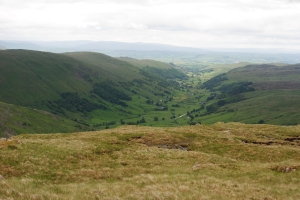
After this stretch of moorland the only option was to head down into Longsleddale again and then up a tortuous zigzag path onto the next ridge. This had to be crossed, along with the ridge after, before the finish, and there were a few controls on each that I felt I had time to run to, though it was very tempting to make a beeline for the finish tent and the hot meal that was waiting. I tried to enjoy the view and found it strangely uplifting – cloud still hung on the high fells to our north and sparks of sunlight fell on the moor. Woodlands crowded the slopes and at one point I was picking my way through one to the promised path, admiring the moss covered boulders and smooth dead wooden branches poking up from the earth.

The final slope, which went up to one control, along a low ridge to another, and then down to the finish, was a procession of people, runners who had all chosen to finish this way. No doubt on some other hill there was another procession finishing via a different option. Navigation is no longer an issue – you follow the march of hobbling, deep breathing men and women, all starting to lose their confident focus. I looked at my watch, mindful of the Dutch father and son I had spoken to the night before who, in the previous year had tried to get one particular control, took far longer than expected, ended up more than half an hour late and got zero points for their efforts. I knew I could finish, but I also wanted to lie down and go to sleep. Every patch of boggy grass looked like an excellent bed. The finish, and associated tents and banners, shot into view less than a kilometre away and a few hundred metres beneath us from the final control. Like a wounded pack of barbarians attacking a well defended Roman fort we stumbled and flung ourselves down the hill, some people clearly running out of time. The last few hundred metres downhill on tarmac were not pleasant. But it was over, and of course it was brilliant.

There are of course times during a two-day event where you question why you are there. Luckily these are outweighed by all the usual things people enjoy – the sense of adventure, the camaraderie, the stunning landscapes, the excitement of finding a control and realising that you can in fact navigate. But more than this, an event like this pushes your body and your mind into places most people never experience, at the height of what you are capable of, not only in endurance but in mental control. I love walking, passing through a landscape and exploring it, but sometimes you need to go beyond this, to get off the path and put yourself into a state where you not only pass through a landscape but embrace it, where you decide to run uphill into the worsening weather because more than finding controls and getting to the finish, you get to experience the mountain and your own limits together, and remember that the mountains are always bigger than you are. It is about looking past the fact that most of the hills are essentially sheep pastures, and that walls and fences and paths are frequently encountered and are used to navigate. It is about experiencing the things we will never tame, the slippery wet rock, the disorienting mist, the fierce wind, the majesty of the sun shining through the cloud onto the watery pools in the marsh, the vision of a single person running through a grand landscape, surrounded by mountains.

The Long Mynd

One of the greatest benefits of being involved in running events in the uplands is that you are constantly discovering areas of the country you have never seen before. This was true a few weeks ago when I went down to the Beacons for the Brecon Beacons fell race. Although I have been up Pen Y Fan and the surrounding peaks several times, the race approached them from the east, over hills I had never looked at twice before. In a similar way, the Source of the Severn race showed me a great route through the forest at the end of the valley where I live. You can always find new adventures close to home!

Orienteering takes this to a whole new level – and introduces you to such detailed navigation that even mountains you know well will suddenly reveal previously undiscovered streams, knolls, or incredible views from wild slopes. It is also a way of seeing parts of the country you have never seen before, and discovering those same unique aspects of hills that even the locals won’t have been to.

It was in this way that I found myself in the Shropshire Hills AONB last Saturday for an orienteering event, the Long Mynd Long O. The Long Mynd is the wide area of raised moorland, described as ‘flat on top’ by one of the marshals, but containing steep drops and cut valleys that definitely felt more like mountain slopes. The mini ridges and furrows running down to the stream beds gave a feeling like a mini-Switzerland, and the views from the heights over Church Stretton and the hills further east were spectacular.

I was doing the Long O as practice for the next weekend’s Rab Mountain Marathon, and was planning to take it easy. There were three courses, names ‘Long’, ‘Longer’ and ‘Longest’. I did the longest, wanting a nice day out with some good time for refreshing navigation. Distances though, unlike standard running races, are far more difficult to predict the time for. At 17.2k, the longest course as a fell run may have taken 1.5 hours. My experience for orienteering is to double the time.

Nevertheless, the fact that you are on your own, left with the time to navigate, out in the hills for as long as you want, does give orienteering that extra bit of adventure. The paths and trails of the Long Mynd took me over hills, down into quiet valleys via fern-soaked hillsides. Trying to take a short-cut I was reduced to fighting my way downhill through thick ferns and heather. Every few steps I would feel my feet tied up into the foliage as it took hold of me and tried to keep me back. It would have been easier to roll. The uphill slopes were just as steep as any fell race in the Lake District or Snowdonia and where running was possible on these sections, it was at a slow mince, head to the ground.

Later on, hours later, the morning haze that had clung to the valley bottoms had risen and the air was warm. I was nearing the end of the course of 12 checkpoints. The difficulty on this course wasn’t the detailed navigation to get to each point, but the route choices that had to be made to get from point to point. It is these decisions, up and down, or around, north or south, that combine to make an efficient or inefficient route. In this way, orienteering can provide a good experience to get people used to exploring real wilderness, having to make decisions about their tactics and route planning with only the information in front of them, and having to commit to a decision. Sometimes it ends up being less efficient, but you learn, and eventually you arrive at the finish, with an excellent journey behind you.

Ferney trail, Mauritius

I woke before dawn to the sound of chirping crickets and light rain pattering on the roof of the Mauritian Wildlife Foundation’s field station at Ferney. The sun rose and cast its light into the valley and onto the hills to reveal the staggeringly beautiful lush green landscape that is La Vallée de Ferney. The clouds dissipated to reveal a clear blue sky and the breeze was cool and refreshing. I don’t think we could have hoped for better weather for running on the morning of the Ferney trail.

Ferney

Ferney in the morning

The Ferney trail has three routes that you can run: 10 km, 17 km, and 35 km. I had entered the 17 km race, which involved 685 m of elevation: not the hardest race that I have ever entered but I was a little nervous about the effect that the heat was likely to have on me.

After jogging the couple of kilometers to the start line, I quivered with anticipation and nerves. I’ve never raced outside of the UK before and I had no idea what to expect. There were many people around me kitted out in very professional looking running gear. They spoke excitedly amongst themselves in French. I guessed that they were from Réunion, which is very mountainous and renowned for producing fantastic trail runners. My nerves heightened.

After the usual chaos of fighting my way past the initial crowd of runners, I found my running rhythm quickly and enjoyed flying along the dirt tracks in between sugarcane fields. As I started to climb the first hill I was surprised to see that I was passing a lot of people: I usually overtake people on the downhill and get overtaken on the uphill. As I continued to climb and passed more people it struck me that one of two things (or a combination of both) must have occurred – either my weekend runs up the hills in the Black River Gorges National Park had really paid off or the runners here were not as comfortable with hills as those back home. Whatever the case, I was delighted.

Up dirt tracks on exposed hills, along single tracks through the forests, and down steep and narrow paths thick with mud: this really was a fantastic trail. The views from the hills were staggering. One particularly beautiful scene was the first time that the Indian Ocean came into view: turquoise blue bay perfectly calm and protected by the outer reef that can be identified by a ring of frothy white water. I kept my eye out for the Mauritius Kestrel (Falco punctatus) but sadly they evaded me (and not for the first time since I moved to Mauritius a month ago). In many places the trails were so thick with red, iron-infused, mud that I had to stop to claw at the lugs from my trail shoes in attempt to gain more purchase and reduce the number of tumbles. Once when doing this I saw a tiny toad – the African common toad (Amietophrynus gutturalis).

LionMountain.2

View of Lion Mountain – a section of the Ferney trail. Photo taken from Ile aux Aigrettes.

I was second lady up until the ‘5 km to go sign’. At this point a woman, who had been very close behind me for some time, had something extra left and pushed ahead. This didn’t bother me too much though because I was confident that if there was a last hill then I could catch her again. Unfortunately, the hill came too late and I couldn’t close the gap that she had created between us. I finished third with a massive smile and plenty of mud on my face.


Race the Train

If you look all over the world trying to find the perfect example of a train that will always leave on time, look no further than Tywyn, on the west coast of Wales. At exactly 14:05 on the third Saturday of August, it sets off inland, up into the Snowdonia National Park, packed as usual with people out to enjoy the countryside; many are young families. Cadair Idris looms above it. But few trains herald the departure of hundreds of runners (over 700 this year), eager to race the train up and down the valley, desperate to be back in Tywyn before it blows the finishing whistle.

We are gathered on the bridge next to the station; over to the right by the registration tent, music is playing and inflatable bouncy castles and slides stand silent. A marshal wearing a high-viz gilet straddles the bridge wall, one leg dangling towards the railway line, watching the train. There is a signal from the driver, a loud horn and cloud of steam and we are off, runners and the train alike. The course is 14 miles with around 280m of ascent, mostly on trails through slippery fields and clinging to hillsides. The train gets to stop at the stations; we don’t stop, we can’t afford to. For 31 years now this race has been going on, and each year between 10-15% of the runners manage to beat the train, which takes 1h48mins to complete the round trip.

I have to admit that the first 5 miles were tough. I had warmed up as usual but the fell race I had run the previous evening had taken its toll and my right leg was threatening to give up. But despite all the misery of those first few miles there are things that no runner should stand – these are, being beaten by anyone wearing a triathlon top, being beaten by anyone wearing a ‘tough mudder’ top, or being beaten by anyone with a stupid running slogan. I saw three people wearing running club tops whose slogan was ‘go hard or go home’. This so appalled me as being against the spirit of running as something enjoyable that I decided I had to beat all of them. Luckily I passed them early and never saw them again. The tough mudder guy, despite taking nearly all his clothes off by half-way, began to fade soon after passing me at breathtaking speed for a 14 mile race. He faded rapidly soon after. I’m not sure what happened to the triathlete.

Through the fields that formed the course on the way up the valley, I tried to enjoy the stunning scenery of southern Snowdonia, the flatness of the valley contrasting sharply with the steep hillsides and hanging woodlands surrounding it.There were regular drinks stops and hundreds of supporters on the sides of the track when we crossed near a road. Infrequently I would hear the steam-powered whistle of the dreaded train, but in my confusion I couldn’t work out if it was ahead or behind. The fields were thick with grass and slippery, and their slight angle made it hard on the ankles. There were some deep footprints in large fresh cow-pats.

After 5 miles I began to relax into a good pace and was enjoying the scenery, and after half-way I was feeling in good spirits, passing the 7 mile mark as we turned, went under a railway bridge and were on the return leg! Immediately after the railway bridge was a short steep hill, which most of us took at a walk. This was followed by a spectacular section along gently undulating hillside path, just wide enough for one person, but not wide enough to pass without leaping up into some gorse bushes. I was quite content to keep to the pace of the guy in front.

The next section apparently passed next to Dolgoch Falls. I can’t verify this as I heard but didn’t see a waterfall. There was definitely a river, which we crossed by bridge, and a lot of bog, which we ran through and in which I nearly lost a shoe and very nearly speared my hand on a nail as I slipped and grabbed a wooden post. Bog over we were sharply downhill, down which I threw myself, and along with several other tall runners dodged low branches for a few hundred metres. I was beginning to wonder where we were when we rejoined the outwards route and were running back into Tywyn. The last few fields had some very friendly marshals which certainly made the experience better despite there being one last steep uphill and some joint-pounding road sections left.

The crowd at the finish was incredible, cheering everyone. A commentator was seamlessly trying to encourage all the runners by name. He announced a few minutes after I finished that current finishers were still beating the train. I was relieved. My legs were now solid. Stretching was not fun. The atmosphere was brilliant though, and I have rarely seen an event so well put on as this one, for its size. Facilities were excellent and there were events for all ages, plus several other variants of ‘race the train’, including 10k, 5 mile and 3 mile races. There was even a goody bag with a t-shirt and snacks. The main race forms the final event in the Welsh Trail Running Championships, which explains the lightning fast times of the winners. But of course, for most of us, for the hundreds of runners and the equal hundreds of supporters and marshals, it’s not about winning, it’s about beating the train.

10377536_687489257966515_2977458193054863478_n

The Berwyns

A recent article on grough about the Berwyns was the first I had heard of this range of hills in central North-East Wales. The article was about a ‘missing’ Berwyn, absent on OS maps but which turned out to be the highest hill of the range. Intrigued about a hill range so unknown that the highest hill had been missed off, I went there for a run.
 
The Berwyns are quite high, peaking at 832m and with three peaks over 800m. They lie just outside the boundary of the Snowdonia National Park, which may explain their relative obscurity. I am sure they have their devotees and are treasured by the locals, but it says something about me, when I think I know the hills of Britain quite well, that I had never heard the name before. 
 
I drove along the small road leading into Cwm Maen Gwynedd looking up and around at the complete darkness and the spitting rain. The darkness itself was good evidence that there were hills there, and as the rain was meant to clear by morning, I pulled off the road somewhere below Rhos and went to sleep in the back of the van. 
 
The morning was bright and sunny, with a few clouds moving quite fast above. The high point of the main ridge, with the ‘missing’ hill Craig Berwyn visible as a jutting rocky peak surrounded by ridgeline and dropping fellside. I set off up one of the long arms of hills leading to this main ridge, running to the start of the steep slopes up Rhos, walking fast up the steepest section, and then breaking back into a run once on the undulating ridge, above 600m and approaching the summit of Rhos. The ground was mostly pathless apart from a few sheep tracks and the vegetation was thick heather with a diverse range of other plants. Apart from some boggy ground above a plantation it was dry but soft.
 
I was soon treated to a panorama of the main Berwyn ridge ahead as the sun came out, though clouds over to the North-West over Snowdonia promised some rain. My run continued over Mynydd Tarw and up to Tomle (742m), hills which provided perfect ascents for training, not too steep to have to walk but long enough to practice some pacing. Rain briefly came and went.
 
From the col before the main ridge I branched off on a track to run up to the summit of Cadair Bronwen, whose substantial summit cairn provided some shelter from the wind that was beginning to pick up. The views were extensive as I turned back around and ran south, now on the main ridge. This section does have recognisable path along it, and even some decking to reduce erosion, by a sign that alerts people to the SSSI status of the northern slopes.
 
Once on the approach to Cadair Berwyn, the ridge smoothes out and the path clings to the brilliantly steep southern slope, which drops back down to a young plantation a few hundred metres below. There is a trig point marking the summit of Cadair Berwyn (827m) and then a circular shelter before the obvious and much higher missing summit, where the rocks break through the soil. The wind had become prohibitive by this point, and somewhere to the West, Arenig Fawr was obscured. I ran along to the end of the high ridge, Moel Sych, and then followed the path down to another arm of hills reaching back into my original valley. 
 
The route over this spongy spur, which is only distinguished by the name ‘Godor’ for the end point, was slow going. Lots of high leg lifting was required and I was sometimes reduced to a walk in deep vegetation. There was periodically an old quad bike track evident on the summit, but the going only got fast again when I reached the top of Godor and began the descent back down to the valley tracks, passing bemused sheep huddling together from the wind.
 
I saw two other people that day, a Sunday in August with moderately good weather, who were both heading from Moel Sych towards Cadair Berwyn. The two hilly arms I had run up and down were without people or paths, and just went to show that the route we choose to get to the high peaks can be just as exciting as gaining the summits themselves. I am pleased to say I now know about the Berwyns, and from what I could see from the top, there are plenty of other valleys and hillsides to explore. There are also a few well defined trails, for those who don’t want the slowing down effect of uncropped vegetation, but I would certainly suggest giving it a go, just to get a true sense of this exceptional area. The route was around 24km with over 1000m of ascent.

Seaview 17

Within the first five miles, several runners in front of me had already taken tumbles, slipping off the side of the path and sprawling, suspended by the rhododendron and the bracken. They clambered back up, assisted by competitors, and continued.

This was only a feature in the first quarter of the Seaview 17, a 20 mile, 1000m ascent trail race from Countisbury to Minehead, mostly following the spectacular south west coast path over the hogs-back cliffs and wooded slopes of Exmoor. The nature of the coast path means that it switches between open track to tiny footpath regularly, adding much excitement to any day out.

To lull us into starting too fast, the first section of the race ran downhill over classic two-person width trail, soily and studded with rocks. We leapt happily downhill, glad that the last few days’ heat was lower than it had been.

Of course I started too fast, and by the time the trail narrowed to a single track through dense coastal trees, roots knotted together through and over the path, I was tired. It is at this point though that you become stuck. I didn’t want to slow down and force those behind me to pass, as this would have ended in more people, possible including me, diving unceremoniously off into the undergrowth, arms first. I kept up the speed till the path became a track, at which point I had to slow down, because it also began to go worryingly uphill.

Finding the right pace is always a good moment as unless you are trying to win, the real point of running is to enjoy yourself. And of course to push yourself, as I would have also enjoyed the scenery by sitting in a pub garden. To enjoy pushing yourself will have to do.

Emerging from the trees to find the first water stop, high above the Bristol Channel was a relieving moment; the next few miles took us along the tracks and fields above the cliffs towards Porlock Weir, descending through more woodland (desperate for shade by this point) to Culbone Church and trying to enjoy the undulating path, surrounded by intense summer greenery, the smell of warm ferns, and the satisfying sound of trainers on cool earth.

Back out of the woods into Porlock Weir, by this point only able to see one or two other runners in front and behind me, we were turned off the road to run along a few hundred metres of stony shingle, which by that point seemed similar to one of the twelve labours of Hercules. The sea on the left was close and inviting, and a brief few miles of flat exercised some different muscles. Ahead now lay the final big climb of the day up Bossington Hill to Selworthy Beacon. Despite being in the open there was no wind.

This near 300-metre climb was taken at what can only be described as an eager walk. A couple on a bench asked me and another runner whether there was an easier way to have fun. I looked at the sea, replied ‘swimming’ and carried on uphill. Somehow it seemed more comforting to watch the sea receding below me that look up at the climb still to come. At the summit, a water station and the knowledge that it’s all downhill from there was encouraging. The Welsh coastline in the distance was clear in the midday sun, and we could see the island further up the Severn Estuary. Wild flowers had accompanied our footsteps and insects were everywhere. This was a good place to be. I met some other runners at this water station; some of them were even smiling.

Five miles of downhill from Selworthy Beacon to Minehead and then along the seafront are an excellent way to finish any race. Suddenly you feel fresher, though my legs disagreed. Back into the woodlands we flew and down some agonising zigzags before Minehead itself came into view and the big white tent of Butlins. I doubt I will ever try and get towards Butlins as desperately as during this race. In the weirder moments of the effects of the heat, I felt my stomach full of water but my mouth dry. I wanted a drink but I didn’t want to swallow it. It was all very confusing.

Crossing the finish line at the Minehead Cricket Club made me very happy. I don’t think ever before have I genuinely thought I couldn’t run another kilometre. After previous races I wanted food; this time I wanted to lie down in the shade, preferably in a paddling pool. For views, and the linear nature of the race (we were bussed to the start) the Seaview is an exceptional journey. Just for the chance to explore part of the south west coast path it would have been worth it, and it certainly feels good to have run the highest cliffs in England.

Skomer Island

It could almost be a riddle. There are 300,000 birds here, on this island, which is small enough to see from end to end and where a circular walk lasts only six kilometres. Yet you can see none of them. They are nearly all nesting, and nearly all have eggs, but you can see no evidence. Why? Because the nests are all underground.

Arriving on Skomer island, greeted by puffins, guillemots and razorbills, we was looking forward to taking a walk along that great transition between the sea and the land. The rocky cliffs, even from the short boat ride, could be seen teeming with wildlife, and the colours of the flowers dusted the slopes with the pink of campion and the white of something I didn’t recognise. As we walked up the slope from the boat, the birds get astonishingly close. It is unusual in this country to have wildlife unafraid, so used are we to animals fleeing at the first sign of people, the only genuine encounter with something wild coming from someone trying to feed a grey squirrel in a London park. The puffins here stand inquisitive and the guillemots, which look like shrunken penguins, tilt their heads, watching you and the sea simultaneously.

To be fair, the lack of fear in the birds could be that this nature reserve lacks any ground predators; foxes, cats and rats have been successfully excluded. As have rich people in tweed with guns.

The first thing you are told to do is to turn round on the top of the path up the cliff and survey the slopes above another cliff a few hundred metres away over the bay. Even without binoculars the holes are obvious, peppering the ground like a chinese chequer board, puffins poking out of some. But these are mostly the burrows of the Manx shearwater, a much rarer bird for which Skomer is an internationally important site. During the day the parents are out at sea, and at night they hide away underground. During the dawn and dusk you can see them leaving and returning en masse, with a legendarily eerie call.

‘Don’t step off the path’ we are told, and made to repeat. Last week a woman sat down off the path and crushed a nest. You begin to walk and you see why. Everywhere there is no path there are burrows, with plants clinging on in-between. Only where there is water and rock do the burrows cease. On an island with only a few small trees, this is by far the most ingenious use of space, and you have to admire the puffins and Manx shearwaters for developing this burrowing ability. It certainly seems like a more attractive option than the guillemots and kittiwakes, huddling on the edges of the sea cliffs with their nests balancing above the void.

As you walk around the circumference of the island the views down onto different cliffs come into sight and then fade, and hundreds of birds are replaced with many more hundreds round the next cove. Enthusiastic photographers huddle together pointing telescopic lenses at lone puffins posing in front of their nests. Now and then a puffin will take off, or one will come in to land, their wide orange feet stretched as far apart as possible, making them look like wingsuit pilots. They do not fly in the most graceful way, but they are fast, and appear from the horizon shooting low over the sea.

The island circuit does not take long to complete, and there is just enough time to head for one of the central bird hides to watch a curlew. It is not an enormous place, but twinned with its surrounding islands Skomer shows how targeted efforts to create nature reserves in vitally important places can have benefits far more than their size would suggest. But it can’t be easy. Surrounding the island is the marine reserve, and just out in St David’s Bay we can see an oil tanker coming in to one of the many refineries around Milford Haven. Talk about life on the edge.

What Skomer also reminded me is that wildlife does not always have to be terrified, fleeing at the first smell of humans. You do not have to go to a zoo to see animals close up. Simply choose to go to somewhere where they have no reason to fear you.

Pania della Croce

Sometimes a full work day means you really have to try hard to find time to get outdoors. And sometimes, when you find yourself somewhere you can’t resist, you just have to get up at 4am and run up that mountain.

In the Alpi Apuane, the Apennine National Park in Tuscany, there is not only a spectacular mountain range, peaking above 2000m in places and providing a mix of dramatic cliffs and ridge-lines asking to be scrambled. Most of the lower mountain slopes are also covered in thick forest, mostly from what I could tell, of beech with a few oaks thrown in. There were undoubtedly more species higher up, and when the woods opened out, steep meadow flanked the rocky summits. We are used to patches of woodland in Britain, and if lucky, even get to walk through sections that almost seem untouched. The Apennine National Park feels like the most sacred and beautiful of our woodlands on a vast scale, the land protected from agriculture and the trees forming an unbroken blanket over large valleys and down precipitous slopes.

Through this landscape there are trails, marked out in the European way by red and white paint on rocks and trees every few tens of metres and on bends. Each trail is numbered, and sometimes signposts are encountered. There is of course a debate as to whether this is appropriate in Britain, and many dislike it, but in Europe it undoubtedly leads to great walking and trail running on mountain slopes that would be too steep to go straight up, and woodland too dense for most regular walkers to find enjoyment.

I had two visits to the mountain valley near the village of Fornovolasco, and after sitting in a van most days, needed the running time. The mountains towering above the village were tempting enough, and so at 5am off I went, following the red line on the map, trying not to trip over in the dawn light, running up towards the ridge. This peak, Monte Forato, is named after a natural limestone arch on the summit of the ridge, like the handle of a giant buried amphora. I came up to it, not knowing it would be there, and there it was, a hole in the mountainside. From an hour staring at trees and the rocks in front of me I could suddenly see the sea, several miles and more than a kilometre beneath me. The ridge from Monte Forato north to Pania della Croce falls away nearly vertically on the western side, whereas the eastern side has grassy slopes above the forest I had climbed through. Along this ridge I ran, the sun making its way gradually over the snow-capped peaks to the east. This kind of running, followed by the rapid descent 900m down the mountainside back to Fornovolasco, is the bit where you can really fly. Before I turned to descend, I took a look up at the monster, Pania della Croce, 600m above me.

Five days later and I was back, on another work day, up at 4am on the only morning in two weeks in Italy that we’d had rain. I ran up through the woods again, my torch pointing at the track, trying to find the red and white paint to stay on course. My shoes slipped in the mud. I wasn’t expecting mud in Italy. Gradually, as I rose higher, the light increased, until when I reached the ridgeline I could make out the path in the gloom, and the mountainsides hummed blue. Clouds filled the valleys beneath me and spilled over the low point in the ridge, a temporary cloudfall. There was Pania della Croce, 1858m high, above me. I startled a herd of mountain goats as I ran up the flaky rock path, steeper than in the woods, causing me to go slower, sometimes to stop. I promised myself that I would turn round at 6am to give time enough to descend.

The path, climbing the flank of the summit cone, reached a point where I could see over to the northern slopes of the mountain. The route had become a game of jumping, trying to keep up a run whilst leaping onto rocks and skirting path hanging over long drops.

The view began to change. There lay another ridge path, to other peaks, and there a high mountain hut. I turned to look at the summit and in front of me was rocky scramble, a sometimes loose fine ridge of limestone. It was good to feel the rock in my hands. It was smooth and cool in the morning, a comforting essence of solid mountain. It was getting on for 6am but there was the summit cone, a well rounded dome from my angle, right above me. With a beating chest I experienced again that reason we mountaineer, to suddenly come face to face with sky on all sides, the mountain around and beneath you. I touched the summit trig point, and looked out over the Apennines, at the sleeping Italian villages and the Tuscan peaks, tooths above their foresty gums, lonely in the morning light. Spreading out from that point were other trails, leading to other peaks through other forests and other adventures. And I turned to run back down mine to the valley below.